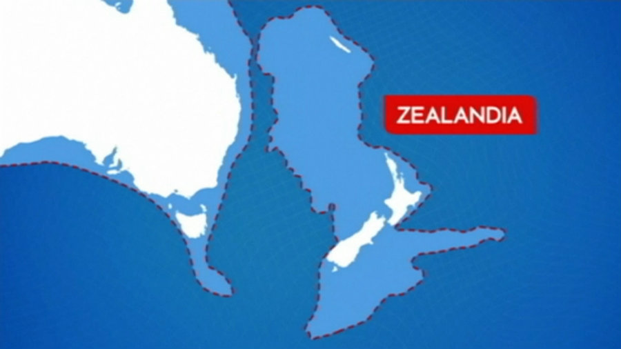
After millions of years that the landmass later-called Zealandia sank into the South Pacific waters, a team of international scientists has finally completed the first exploration to collect samples of this seabed. On Wednesday, this same landmass was declared the Earth’s newest continent – which includes Lord Howe Island off the east coast of Australia, New Caledonia, and New Zealand.
The scientists traveled to recollect proofs and understand a little more if they could actually call Zealandia a continent. On Wednesday, after nine weeks of research, the 32 explorers from 12 countries arrived in Hobart, Tasmania, aboard the research vessel JOIDES Resolution, with new impressive findings.
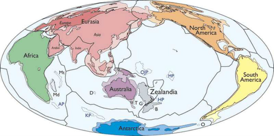
The geophysicist and oceanographer Bruce Luyendyk named the landmass “Zealandia” in 1995. Since then, geologists and academics have debated whether or not to recognize it as a continent.
Prof Rupert Sutherland from New Zealand’s Victoria University said the expedition had discovered “big geographic changes.”
“The discovery of microscopic shells of organisms that lived in warm shallow seas, and spores and pollen from land plants, reveal that the geography and climate of Zealandia were dramatically different in the past,” Professor Gerald Dickens of Rice University told The Guardian.
Scientists believe Zealandia separated from Australia and Antarctica, as part of Gondwana. Rupert Sutherland, the expedition co-chief scientist of Victoria University of Wellington in New Zealand, believes that this is “probably accurate, but it is now clear that later dramatic events shaped the continent we explored on this voyage.”
The new continent measurer 5 million kilometers of large, from edge to edge – almost the same length of the Indian subcontinent.
20 years after, Zealandia is called a continent
The group of researchers went 4,000 feet deep down the ocean and collected around 8,000 feet of sediments from the floor – at six different sites across Zealandia. They discovered fossil and evidence of large-scale tectonic movements. Thus, providing the world new findings of a landmass that’s believed has been covered with water for more than 70 million years.
The new continent could have actually been closer to the surface than it was believed before. It might have been a pathway that wildlife used to migrate from one place to another. This discovery could give the scientific community more to understand how plants and animal species did to expand since the beginning.
The discovery shows that the formation of the “Pacific Ring of Fire” – a major area in the basin of the Pacific Ocean where a large number of earthquakes and volcanic eruptions occur – buckled the seabed of Zealandia, according to Dickens.
Further expeditions are going to be made on next year around New Zealand, Australia and Antarctica, now that it has been demonstrated that Zealandia is indeed a continent. The researchers said that one thing on their bucket list is to know more about the new continent’s climate history.
“Zealandia is everywhere substantially elevated above the surrounding oceanic crust,” the study says. “Whereas most of Zealandia’s crust is thinner than the 30–46km that is typical of most continents, studies show that it is everywhere thicker than the 7km-thick crust of the ocean basins. “
Source: Geological Society of America