Using satellite imagery, researchers from Stanford were able to assess poverty rates from Rwanda, Uganda, Tanzania, Nigeria, and Malawi, revealing variations of the economy and state of income of the average citizens.
The process is based on machine learning and only requires the use of publicly available information. The research team has highlighted that there is not enough census data to assess global levels of poverty. The primary factor in determining the level poverty of each region was nighttime lighting. The researchers were inspired by the fact that nighttime maps of the earth show that developing countries and those under detrimental economic situations are dimly illuminated.
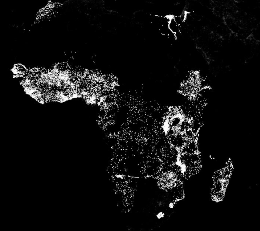
Poverty puts countries in the dark
The study was published in the journal Science and was co-authored by Marshall Burke, from Stanford’s Department of Earth System Science. Burke explained that there is not enough data concerning the number of households in every country and their economic situation, mainly because these surveys can be expensive and difficult to develop in regions whose resources are not immediately available.
The team analyzed high-resolution pictures taken by satellite. Stefano Ermon, a specialist in computer science who took part in the study, explained that the photos were subjected to a machine learning computer model to determine the relation between the lack of nighttime illumination and poverty rates in a specific region.
The system was provided with day and night photos and it was programmed to perform assessments on poverty level. By comparing both sets of images, the model developed an algorithm to try and predict the economic situation of each region.
The system was provided with day and night photos and it was programmed to perform assessments on poverty level. By comparing both sets of images, the model developed an algorithm to try and predict the economic situation of each region.
It also took into account roads, urban areas, farms, and unaltered landscapes. All of these are indicators of either rural or urban civilization, which in part have an intrinsic relation with the perceived level of poverty in a region.
The model received over 330,00 images, where over half were considered to have zero nighttime intensity. This was fundamental for the research as the computer model had to be “taught” to first take into account the more reliable images to then try and analyze the ones that showed lesser nighttime illumination.
The challenge lies in trying to correlate the transfer of knowledge from perceived light intensity to the distribution of marginality. Ermon presented the research at the 30th AAAI Conference on Artificial Intelligence and compared the experience to driving a car and then driving a motorcycle.
The computer model made predictions on poverty levels through the reviewing of photographs. When the researchers compared the results to official numbers released by census operatives, they discovered that the computer model was very close to reality.
The model is understandable only up to a certain level, as it is a machine learning system model. It was stated that the researchers can only guess how the model is making the associations, as it is programmed to find solutions by itself from the data it has received at the initial stage.
“This offers an unbelievable opportunity for cheap, scalable and surprisingly accurate measurement of poverty. And the beauty with developing and working with these huge data sets is that the models should do a better and better job as they accumulate more and more information,” stated Burke.
A new method for obtaining data on poverty
This research method is relatively cheap when compared to census efforts, as there are no known massive underground countries whose population has to be assessed.
Because nighttime light intensity can be a crucial factor when determining levels of poverty, this will allow scientists to circumvent the data provided by governments, which is oftentimes limited by their resources or their political views.
Even with the apparent progress, there is still not enough data to continue. The research team suggests that there is a need for more imagery to provide the machine learning model with more data. As it receives more data, it is able to learn more and to provide better results.
Reportedly, researchers are working with companies to obtain daily high-resolution images of the planet to have enough data to input on the computer model. Burke believes that accurate mapping for demographic research from space is very close from becoming a common reality.
This new transfer learning approach is ideal for high-level representation of data, as it is a cheap and scalable method for collecting data and making use out of it. The team highlighted that their research appears to be better than most poverty level assessments, which proves that machine learning can be fundamental for analyzing obstacles in global sustainability.
Other applications of these methods could serve to learn more about global warming, pollution, demographic studies, and anything where the data proves to be plentiful and there is the need for a computer to draw lines between each factor that can be deemed of importance.
Source: Stanford Press