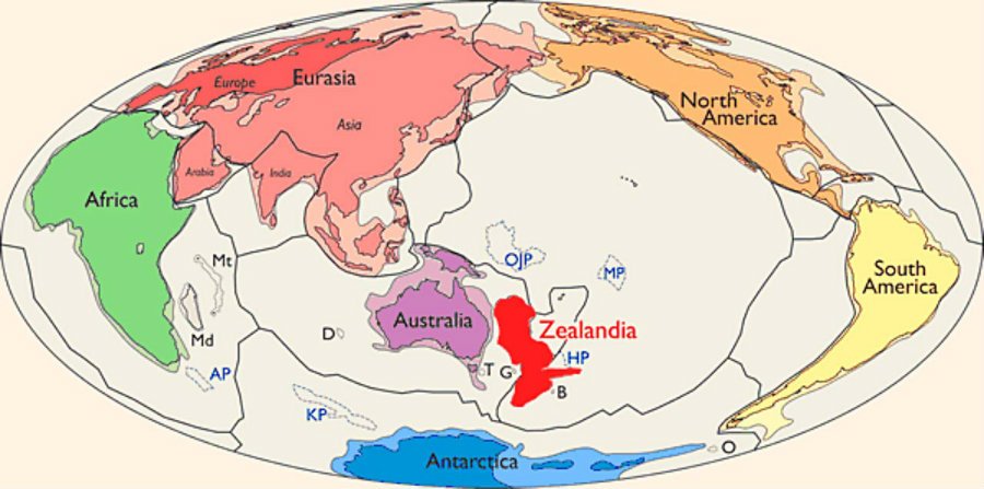
Geologists argue that Zealandia, a name used by biologists and geologists to call a shallow submerged region between New Zealand and New Caledonia, should be recognized as a continent.
Mentions of Zealandia have been around for some time. Geologists at GNS, New Zealand’s “leading provider of Earth, geoscience and isotope research and consultancy services,” as described on their website, have talked about it for the last 20 years, and many New Zealanders are well familiar with the term. But a formal scientific paper issued in the March/April publication of The Geological Society of America has helped spread the term and lead to a shared interest.
There is no official organization in charge of handing over the title, so researchers like Nick Mortimer, GNS geologist and principal author of the paper, hopes that his colleagues will coincide to call it a continent.
Only recent investigations have collected sufficient data to write the paper that geologists at GNS had been expecting for a long time. Mortimer and his team used geologic and geophysical tools like dredging rocks off the seafloor to analyze and date them. Samples from the more distant parts of Zealandia helped put together the paper to propose the idea to the scientific world.
There is no one commonly accepted way to define what a continent is. The meaning of the word is quite inconsistent depending on whether it is a geographer or a geologist using the term.
“The results are pushing us to rethink how broadly we can or should apply the established definition of geological continental landmasses,” said Patricia Durance, a mineral geologist at the GNS Science in New Zealand, according to Nature.
Mortimer hopes that Zealandia will soon become as familiar as other continents taught in school. For the geologist, getting to the stage of having published a scientific work on Zealandia is very gratifying.
What we know about the new continent
Geological data suggests that the region is a single piece separated from Australia and large enough – 5 million square kilometers – to be considered a whole other continent.
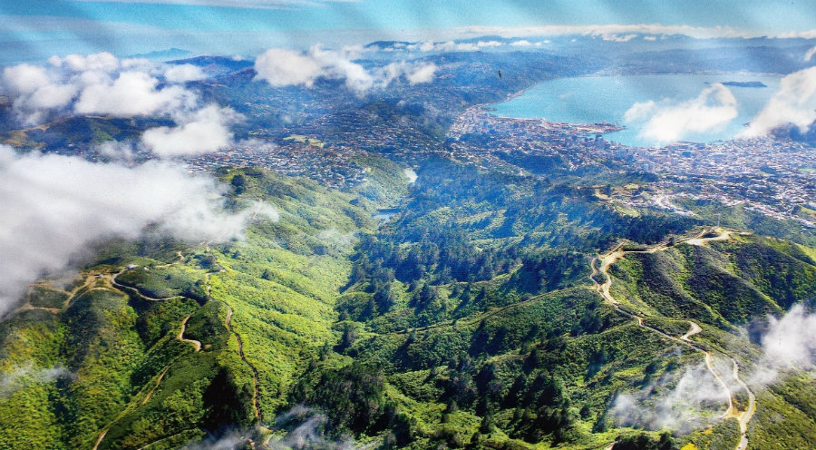
Mortimer and his fellow researchers reported that Zealandia began to break away from the supercontinent Gondwana about 100 million years ago. The splitting pulled and thinned the crust, causing most of the landmass to sink. Today, only 6 percent of Zealandia remains above water, which is what we know today as New Zealand and New Caledonia.
Mortimer explained that all continents have submerged parts and the definition should be geological rather than geographical.
Satellite maps made using Earth’s gravitational field were also included in the study to support the case for Zealandia. The maps show that it is a geographical feature that used to join edges with Australia’s northeast coast and stretches way past the north and south islands of New Zealand.
The author of the paper also stated that Zealandia is always changing shape thanks to the movement of the Pacific and Australian tectonic plates. He predicted that in tens of millions of years the north piece of Zealandia will move so far north causing it to split in two.
Judging from the rock record studied, the new continent has been emerging from the bottom of the ocean since 30 million years ago and will probably continue to rise out of the sea, Mortimer said. The sea-floor analysis also detected that Zealandia consists of light continental crust, as opposed to the dark volcanic rocks that form nearby underwater plateaus.
Mortimer concluded that no matter what it is called, research on Zealandia should help biogeographers shine more light on the distant background of New Zealand’s plant and animal life, and geologists take learning about continental crust changes to a new level.
Source: Nature